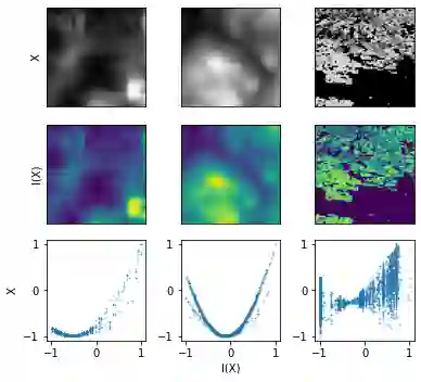
Machine learning is gaining popularity in a broad range of areas working with geographic data, such as ecology or atmospheric sciences. Here, data often exhibit spatial effects, which can be difficult to learn for neural networks. In this study, we propose SXL, a method for embedding information on the autoregressive nature of spatial data directly into the learning process using auxiliary tasks. We utilize the local Moran's I, a popular measure of local spatial autocorrelation, to "nudge" the model to learn the direction and magnitude of local spatial effects, complementing the learning of the primary task. We further introduce a novel expansion of Moran's I to multiple resolutions, thus capturing spatial interactions over longer and shorter distances simultaneously. The novel multi-resolution Moran's I can be constructed easily and as a multi-dimensional tensor offers seamless integration into existing machine learning frameworks. Throughout a range of experiments using real-world data, we highlight how our method consistently improves the training of neural networks in unsupervised and supervised learning tasks. In generative spatial modeling experiments, we propose a novel loss for auxiliary task GANs utilizing task uncertainty weights. Our proposed method outperforms domain-specific spatial interpolation benchmarks, highlighting its potential for downstream applications. This study bridges expertise from geographic information science and machine learning, showing how this integration of disciplines can help to address domain-specific challenges. The code for our experiments is available on Github: https://github.com/konstantinklemmer/sxl.
翻译:在一系列与地理数据合作的领域,例如生态学或大气科学领域,机器学习越来越受欢迎。在这里,数据往往展示空间效应,这在神经网络上可能难以学习。在本研究中,我们提议SXL,这是将空间数据自动递增性质的信息直接用辅助任务嵌入学习过程的一种方法。我们利用当地Moran's I,即当地空间自动调节关系的流行测量,以“利用”模型学习当地空间效应的方向和规模,补充主要任务的学习。我们进一步将Moran's I 的新扩展为多项分辨率,从而同时在较长和较短的距离上捕捉空间互动。新颖的多分辨率Moran's I可以很容易地构建,作为多维度的阵列,将它与现有的机器学习框架相接合。在使用真实世界数据的一系列实验中,我们的方法如何不断改进对神经网络进行不固定和监管的学习任务的培训。在感化空间模型实验中,我们提议对辅助任务GAN'I'进行新的损失,利用任务不确定性重量来捕捉测空间空间空间实验室的地理标准。我们的方法将空间- 的跨空间空间空间空间空间空间实验室应用应用的分级研究,可以显示其地理分级的分级的分级科学分级的分级的分级的分级的分级的分级研究。