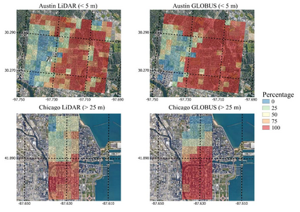
Urban weather and climate studies continue to be important as extreme events cause economic loss and impact public health. Weather models seek to represent urban areas but are oversimplified due to data availability, especially building information. This paper introduces a novel Level of Detail-1 (LoD-1) building dataset derived from a Deep Neural Network (DNN) called GLObal Building heights for Urban Studies (GLOBUS). GLOBUS uses open-source datasets as predictors: Advanced Land Observation Satellite (ALOS) Digital Surface Model (DSM) normalized using Shuttle Radar Topography Mission (SRTM) Digital Elevation Model (DEM), Landscan population density, and building footprints. The building information from GLOBUS can be ingested in Numerical Weather Prediction (NWP) and urban energy-water balance models to study localized phenomena such as the Urban Heat Island (UHI) effect. GLOBUS has been trained and validated using the United States Geological Survey (USGS) 3DEP Light Detection and Ranging (LiDAR) data. We used data from 5 US cities for training and the model was validated over 6 cities. Performance metrics are computed at a spatial resolution of 300-meter. The Root Mean Squared Error (RMSE) and Mean Absolute Percentage Error (MAPE) were 5.15 meters and 28.8 %, respectively. The standard deviation and histogram of building heights over a 300-meter grid are well represented using GLOBUS.
翻译:城市气象和气候研究仍然是重要的,因为极端事件造成经济损失和影响公共健康。天气模型试图代表城市地区,但由于数据可用性,特别是建筑信息,因此过于简化。本文介绍了由深神经网络(DNN) 称为Global Building highs for 城市研究(GLOBUS) 产生的新型详细-1(LoD-1)建筑数据集。GLOBUS使用开放源数据集作为预测器:高级陆地观测卫星(ALOS) 数字地面模型(DSM) 实现了使用航天飞机雷达地形飞行任务数字升迁模型(DEM) 数字升迁模型(DEM) 、 大地扫描人口密度和建筑足迹的标准化。GLOBUS的建筑信息可以在Nucal天气预报(NWP)和城市能源-水平衡模型(DNNNNNNN)中存储。GLOBUS的建筑数据可以分别用于300号地平面平面平面平面平面平面平面平面平面平面平面平面平面平面平面平面平面平面平面平面平面平面平面平面平面平面平面平面平面平面平面平面平面平面平面平面平面平面平面图。


