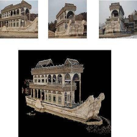
A polarization camera has great potential for 3D reconstruction since the angle of polarization (AoP) and the degree of polarization (DoP) of reflected light are related to an object's surface normal. In this paper, we propose a novel 3D reconstruction method called Polarimetric Multi-View Inverse Rendering (Polarimetric MVIR) that effectively exploits geometric, photometric, and polarimetric cues extracted from input multi-view color-polarization images. We first estimate camera poses and an initial 3D model by geometric reconstruction with a standard structure-from-motion and multi-view stereo pipeline. We then refine the initial model by optimizing photometric rendering errors and polarimetric errors using multi-view RGB, AoP, and DoP images, where we propose a novel polarimetric cost function that enables an effective constraint on the estimated surface normal of each vertex, while considering four possible ambiguous azimuth angles revealed from the AoP measurement. The weight for the polarimetric cost is effectively determined based on the DoP measurement, which is regarded as the reliability of polarimetric information. Experimental results using both synthetic and real data demonstrate that our Polarimetric MVIR can reconstruct a detailed 3D shape without assuming a specific surface material and lighting condition.
翻译:由于两极分化角度(AoP)和反射光的极化程度(DoP)与物体表面正常状态相关,极化照相机对于3D重建具有巨大的潜力。在本文中,我们提议了一种叫“极光多视反反向导”的新颖的3D重建方法(Polariter MVIR),该方法有效地利用从输入的多视图色极化图像中提取的几何、光度和极地分线信号,有效地利用从多视图色极化图像中检测出来的四种可能的模糊的方位角。我们首先估计照相机通过以标准结构(从感应到多视图立体立体管管)的几何结构构成和最初的3D模型。然后我们利用多视图RGB、AoP和多视角图像优化光度误差和对极度误差的初始模型来改进初始模型。 我们提出一种新的极地测量成本功能,从而有效地制约了从输入的多视图色极化图像中揭示出的四种可能模糊的方位方位角度角度。对地测量成本的重量根据多P测量测量结果有效确定,而这种测量数据被视为是极地-D度资料的可靠性。假设地基地平地表的模型的精确度数据,假设了我们具体的地表和精确度的模型的模型的重建结果。