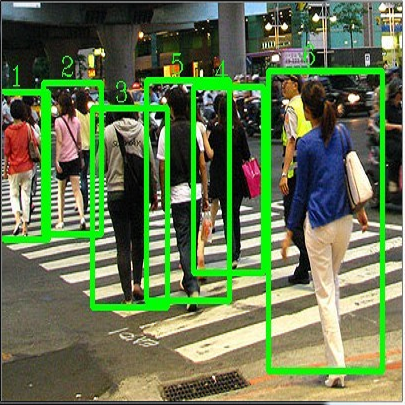
In this paper, we present the solution of roadside LiDAR object detection using a combination of two unsupervised learning algorithms. The 3D point clouds data are firstly converted into spherical coordinates and filled into the azimuth grid matrix using a hash function. After that, the raw LiDAR data were rearranged into spatial-temporal data structures to store the information of range, azimuth, and intensity. Dynamic Mode Decomposition method is applied for decomposing the point cloud data into low-rank backgrounds and sparse foregrounds based on intensity channel pattern recognition. The Triangle Algorithm automatically finds the dividing value to separate the moving targets from static background according to range information. After intensity and range background subtraction, the foreground moving objects will be detected using a density-based detector and encoded into the state-space model for tracking. The output of the proposed model includes vehicle trajectories that can enable many mobility and safety applications. The method was validated against a commercial traffic data collection platform and demonstrated to be an efficient and reliable solution for infrastructure LiDAR object detection. In contrast to the previous methods that process directly on the scattered and discrete point clouds, the proposed method can establish the less sophisticated linear relationship of the 3D measurement data, which captures the spatial-temporal structure that we often desire.
翻译:在本文中,我们展示了路边LIDAR天体探测的解决方案,使用了两种不受监督的学习算法。 3D点云数据首先转换成球座坐标, 并用散列函数填入方位网格矩阵。 之后, 原始的LIDAR数据被重新排列成空间时空数据结构, 以存储射程、 方位和强度等信息。 动态模式分解方法用于将点云数据分解成低位背景和根据强度频道模式识别的稀疏地表层。 三角阿尔戈里特姆自动找到分割值, 将目标从静态背景中分离出来, 按范围信息进行。 在强度和范围背景减色后, 将前方移动物体用基于密度的检测器进行检测, 并编码为州空间模型的跟踪模型。 拟议模型的输出包括车辆轨迹, 以便能够进行许多移动和安全应用。 该方法经过商业交通数据收集平台验证, 并被证明是基础设施LIDAR天体物体探测的有效和可靠的解决方案。 在深度数据测量中, 与先前的精确度测量方法相比, 我们的深度测算方法可以直接测量。