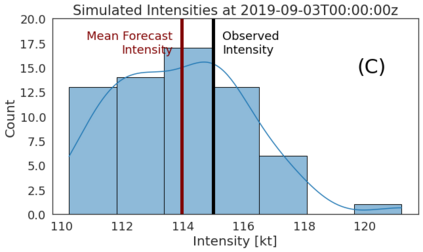
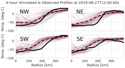
Geostationary satellite (GOES) imagery provides a high temporal resolution window into tropical cyclone (TC) behavior. We present a new method for probabilistic forecasting not only of TC intensity but also TC convective structure as revealed by GOES. This paper describes a prototype model based solely on observed infrared imagery and operational intensity estimates up to 6 hours prior to the current time. These structural forecasts simulate the spatio-temporal evolution of the radial profiles of cloud-top temperatures over the subsequent 12 hours. Our structural forecasting pipeline applies a Deep Autoregressive Generative Model (PixelSNAIL) to create probabilistic forecasts of the evolution of these functions over time. A standard convolutional neural network (trained for ``nowcasting'', or predicting the current response based on prior response and current features) is then applied to simulated structural trajectories to estimate the current intensity and forecast intensities at +6 and +12 hours. Intensity guidance from our prototype model achieves a marginally higher error than the National Hurricane Center's official forecasts. However, our prototype model does not account for environmental factors such as vertical wind shear and sea surface temperature. We also demonstrate that it is possible to reasonably predict short-term evolution of TC convective structure as depicted by infrared imagery, producing interpretable structural forecasts that may be valuable for TC operational guidance.
翻译:地球静止卫星(GOES)图像为热带气旋(TC)行为提供了一个高时间分辨率窗口。我们提出了一个新的方法,不仅对技术合作强度进行概率预测,而且根据GOES所揭示的三角对流结构进行概率预测。本文描述一个仅仅基于观察红外图像和运行强度估计的原型模型,目前之前6小时;这些结构性预测模拟了云顶温度辐射剖面在随后12小时内的瞬时演进。我们的结构预测管道采用了深自动递增生成模型(PixelSNAIL),以建立这些功能在一段时间内演变的概率预测。一个标准的革命神经网络(为“播送”而培训,或根据先前的反应和当前特点预测当前的反应)随后应用到模拟结构轨迹,以估计云顶温度的当前强度并预测在+6和+12小时内的强度。我们原型模型的强度指导比国家飓风中心的官方预测略高一点误差。然而,一个标准革命神经神经网络(为“Nowncrowrowcrowcrowing't ”,或根据以前的反应预测预测预测预测预测当前情况预测的当前结构),然后用于模拟结构结构图层预测,我们可能通过垂直的地震的地震模型进行。 我们的地震结构模型对地震预测进行解释。 我们的地震模型的地面预测的地震结构的地震结构的地震结构的预测是用来用来进行合理的地面预测。


