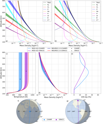
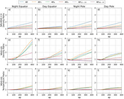
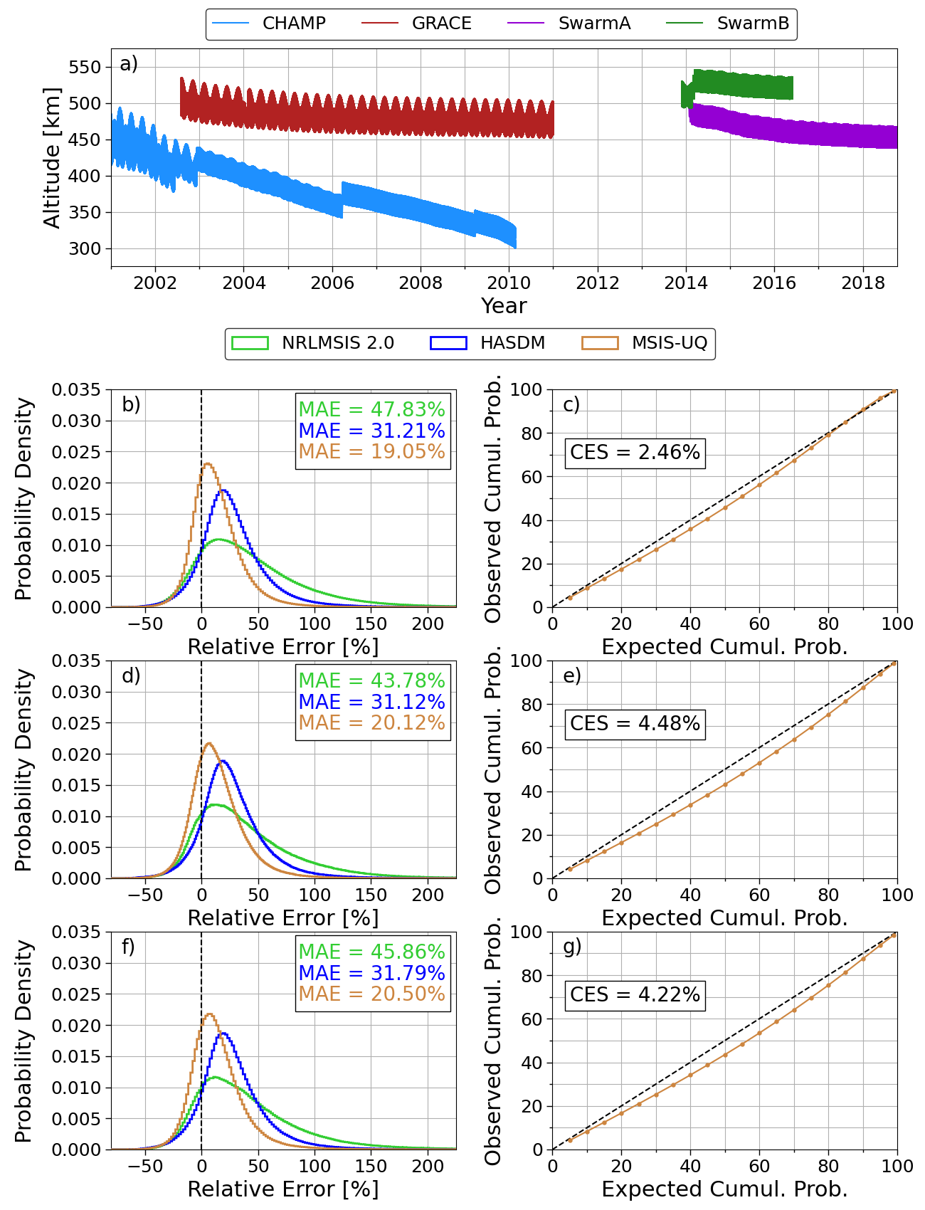
The Mass Spectrometer and Incoherent Scatter radar (MSIS) model family has been developed and improved since the early 1970's. The most recent version of MSIS is the Naval Research Laboratory (NRL) MSIS 2.0 empirical atmospheric model. NRLMSIS 2.0 provides species density, mass density, and temperature estimates as function of location and space weather conditions. MSIS models have long been a popular choice of atmosphere model in the research and operations community alike, but - like many models - does not provide uncertainty estimates. In this work, we develop an exospheric temperature model based in machine learning (ML) that can be used with NRLMSIS 2.0 to calibrate it relative to high-fidelity satellite density estimates. Instead of providing point estimates, our model (called MSIS-UQ) outputs a distribution which is assessed using a metric called the calibration error score. We show that MSIS-UQ debiases NRLMSIS 2.0 resulting in reduced differences between model and satellite density of 25% and is 11% closer to satellite density than the Space Force's High Accuracy Satellite Drag Model. We also show the model's uncertainty estimation capabilities by generating altitude profiles for species density, mass density, and temperature. This explicitly demonstrates how exospheric temperature probabilities affect density and temperature profiles within NRLMSIS 2.0. Another study displays improved post-storm overcooling capabilities relative to NRLMSIS 2.0 alone, enhancing the phenomena that it can capture.
翻译:自1970年代初以来,质量光谱度和不相容散射雷达模型系列已经开发并改进。最新版的MSIS模型是海军研究实验室(NRL) MSIS 2.0 实证大气模型。NRLMSIS 2.0 提供物种密度、质量密度和温度估计,作为位置和空间天气条件的函数。MSIS模型长期以来一直是研究和作业界对大气模型的流行选择,但与许多模型一样,并不提供不确定性估计。在这项工作中,我们开发了一个基于机器学习(ML)的外层温度模型,该模型可与 NRLIS 2.0 对照,使其与高纤维性卫星密度估计值相对校准。我们的模型(称为MSIS-UQ)输出的分布,不是提供点估计值,而是使用一种称为校准误差评分的尺度进行评估。我们表明,MSIS-UQ的下降力模型与卫星平均密度之间的差异为25%,而且接近卫星密度的11%,而空间部的高级精度卫星遥感卫星遥感遥感遥感遥感模型的测量模型中,我们还明确展示了该模型的精确度测测测测测测测测测测度。


