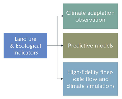
Urban areas are not only one of the biggest contributors to climate change, but also they are one of the most vulnerable areas with high populations who would together experience the negative impacts. In this paper, we address some of the opportunities brought by satellite remote sensing imaging and artificial intelligence (AI) in order to measure climate adaptation of cities automatically. We propose a framework combining AI and simulation which may be useful for extracting indicators from remote-sensing images and may help with predictive estimation of future states of these climate-adaptation-related indicators. When such models become more robust and used in real life applications, they may help decision makers and early responders to choose the best actions to sustain the well-being of society, natural resources and biodiversity. We underline that this is an open field and an on-going area of research for many scientists, therefore we offer an in-depth discussion on the challenges and limitations of data-driven methods and the predictive estimation models in general.
翻译:城市地区不仅是气候变化的最大促成者之一,也是人口众多的最脆弱地区之一,它们都会共同遭受负面影响。在本文件中,我们讨论了卫星遥感成像和人工智能带来的一些机会,以便自动测量城市的气候适应情况。我们提出了一个框架,将人工智能和模拟结合起来,可能有益于从遥感图像中提取指标,并有助于预测这些与气候适应有关的指标的未来状况。当这些模型变得更稳健并用于现实生活中应用时,它们可能帮助决策者和早期反应者选择最佳行动,以维持社会、自然资源和生物多样性的福祉。我们强调这是一个开放的领域,是许多科学家持续研究的领域,因此我们深入讨论数据驱动的方法和一般预测估计模型的挑战和局限性。

