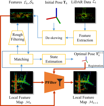
Simultaneous localization and mapping (SLAM) based on laser sensors has been widely adopted by mobile robots and autonomous vehicles. These SLAM systems are required to support accurate localization with limited computational resources. In particular, point cloud registration, i.e., the process of matching and aligning multiple LiDAR scans collected at multiple locations in a global coordinate framework, has been deemed as the bottleneck step in SLAM. In this paper, we propose a feature filtering algorithm, PFilter, that can filter out invalid features and can thus greatly alleviate this bottleneck. Meanwhile, the overall registration accuracy is also improved due to the carefully curated feature points. We integrate PFilter into the well-established scan-to-map LiDAR odometry framework, F-LOAM, and evaluate its performance on the KITTI dataset. The experimental results show that PFilter can remove about 48.4% of the points in the local feature map and reduce feature points in scan by 19.3% on average, which save 20.9% processing time per frame. In the mean time, we improve the accuracy by 9.4%.
翻译:移动机器人和自主车辆普遍采用基于激光传感器的同步本地化和绘图(SLAM)系统。这些SLAM系统需要用有限的计算资源支持准确本地化,特别是点云登记,即在全球协调框架内对在多个地点收集的多个LIDAR扫描进行匹配和对齐的过程,被认为是SLAM的瓶颈步骤。在本文中,我们建议采用一个功能过滤算法(Phililter),可以过滤无效特性,从而大大缓解这一瓶颈。同时,由于仔细调整的特征点,总注册准确性也得到了提高。我们把Philter纳入成熟的扫描到图像LiDARodology框架(F-LOAM),并评价其在KITTI数据集上的性能。实验结果表明,Philter可以删除当地特征地图中大约48.4%的点,并将扫描的特征点平均减少19.3%,这可以节省每个框架的20.9%的处理时间。在平均时间里,我们将Philter的准确性提高9.4%。

