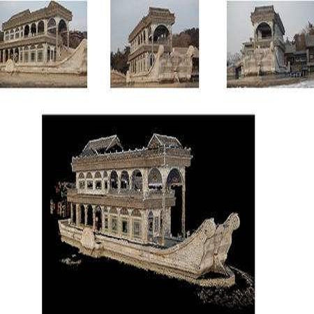
Drones will revolutionize 3D modeling. A 3D model represents an accurate reconstruction of an object or structure. This paper explores the design and implementation of ARES, which provides near real-time, accurate reconstruction of 3D models using a drone-mounted LiDAR; such a capability can be useful to document construction or check aircraft integrity between flights. Accurate reconstruction requires high drone positioning accuracy, and, because GPS can be in accurate, ARES uses SLAM. However, in doing so it must deal with several competing constraints: drone battery and compute resources, SLAM error accumulation, and LiDAR resolution. ARES uses careful trajectory design to find a sweet spot in this constraint space, a fast reconnaissance flight to narrow the search area for structures, and offloads expensive computations to the cloud by streaming compressed LiDAR data over LTE. ARES reconstructs large structures to within 10s of cms and incurs less than 100 ms compute latency.
翻译:3D模型代表一个物体或结构的精确重建。本文探讨ARES的设计和实施,ARES提供几乎实时、准确的3D模型的重建,使用无人驾驶的LIDAR;这种能力可用于在飞行之间记录建筑或检查飞机完整性。准确的重建需要高的无人驾驶飞机定位精确度,而且由于全球定位系统可以准确性,ARES使用SLAMM。然而,在这样做时,它必须处理若干相互竞争的限制:无人驾驶电池和计算资源、SLAM错误积累和LIDAR分辨率。ARES使用谨慎的轨迹设计来在这个限制空间找到一个甜点,快速侦察飞行来缩小结构的搜索区域,并通过将压缩的LDAR数据流到LTE上,将昂贵的计算结果卸到云层上。ARES将大型结构重建到10厘米以内,造成低于100米的拉特。